The Evolution and Applications of Environmental Twin Technology: Webinar Insights

This article follows up on insights shared during the Pennsylvania Geospatial Coordinating Board’s recent webinar on AI-powered digital twins and quality of life innovations, featuring Kat Kraft, VP of Market Development at Teren. The environmental technology landscape is undergoing a remarkable transformation, with digital twins emerging as a powerful tool for understanding and managing our […]
Strange Bumps in the DTM: How Teren’s LiDAR Analytics Helped A Renewable Energy Investor See the True Terrain
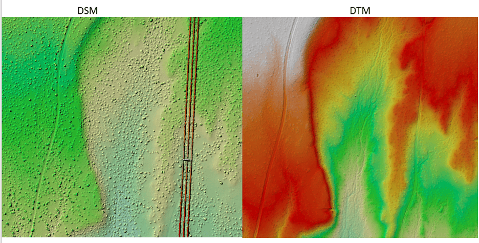
We think there are holes in the digital terrain model. That’s what an engineering firm flagged to Teren’s customer, a renewable energy investor, when they received Teren’s advanced LiDAR and analytics for a project on a solar generation facility out in Southeast New Mexico. Teren’s work with the renewable energy investor started early 2024 to […]
Pipeline Integrity Management: Protecting Critical Infrastructure from Natural Force Threats
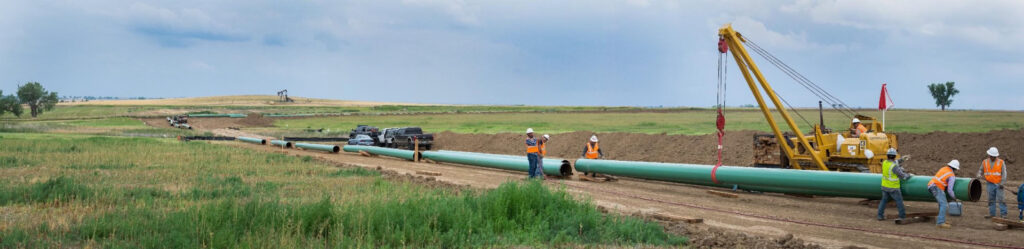
Introduction Pipeline infrastructure serves as the backbone of global energy networks, delivering the resources that power industries and homes alike. Yet, these critical systems face unprecedented challenges from natural forces, which cause hundreds of pipeline incidents costing millions each year, according to the Pipeline and Hazardous Materials Safety Administration (PHMSA). In this guide, we delve […]
Debris Flows: Understanding Nature’s Destructive Geological Phenomenon

Introduction Nature has few forces as swift and destructive as debris flows. These geological phenomena are more than just landslides – they’re powerful, unpredictable forces that can change terrain in an instant. They occur in a wide variety of environments and generally happen during intense rainfall or rapid snowmelt, often starting on hillsides or mountains. […]
8 Ways Geospatial Data Transformed Business Applications in 2024
Geospatial data has transformed the way humans and businesses interact and engage. By leveraging the power of location, we can extract insights, identify patterns, and solve critical problems. To appreciate the power of location, here are eight ways geospatial data is being leveraged in business today. 1. Spatial Analysis and Modeling for Business Optimization 2. […]
Predicting Landslides: Teren’s Hydrology Modeling Validated by Hurricane Helene

In the wake of Hurricane Helene, Teren worked with USGS data to validate its innovative approach to predicting landslides triggered by extreme weather events. Mapping the Risks: Before and After Helene The study used Teren’s slope stability analysis, which calculates a balance between resisting and driving forces in soil. The analysis began with a pre-Helene […]
Building Transportation Resilience: 5 Key Analytics to Manage Increasing Environmental Threats
In today’s rapidly changing climate, transportation infrastructure faces growing challenges from environmental and climate-related hazards. Roads, highways, railways, and critical transit corridors are increasingly vulnerable to extreme weather events, shifting climate patterns, and other environmental risks. Addressing these risks requires a robust suite of advanced analytics to inform proactive planning, prioritize investments, and support resilient […]
Spooky Sightings from Above: Our Favorite Haunted Data Sets

Mappy Halloween from Teren! This October, we’re celebrating the spooky side of geospatial data. From the mapping of haunted sites around the world, to geospatial investigations of the paranormal. Check out our favorite picks below and get mapping! The Spookiest Places in the U.S. (and the Least Spooky) To look at how spooky U.S. metro […]
Enhancing site suitability surveying: 5 key spatial data approaches for pre-construction site engineers and surveyors

For site engineers and surveyors, pre-construction surveying is a critical phase that sets the stage for a smooth construction process. Leveraging advanced analytics of grade, hydrology, soils, and vegetation can create highly useful “constructability” metrics that drive decision making for the rest of the project. Let’s explore 5 key spatial data approaches that can make […]
10 Game-Changing Analytics for Modern Forestry and Land Stewardship

In the ever-evolving field of land and forestry management, the ability to analyze and interpret data has become crucial for sustainable decision-making. With the integration of advanced analytics, professionals can now monitor and manage natural resources more effectively, ensuring that forests and openlands are preserved for future generations. Here, we explore 10 key analytics shaping […]