For forest, water resource and emergency planners and managers, data science and digital twins are the new necessities for effective, defensible watershed and disaster management decisions.
Teren’s suite of actionable forest, watershed and disaster data products harmonize LiDAR data with contextual datasets to create and analyze dynamic digital twins of the natural and human worlds.
Reclaim burn areas & regenerate ecosystem function
Reveal where action is needed most after a wildfire to protect human lives and infrastructure, prevent further disasters, and quickly regenerate ecosystem function.
Prioritize treatment zones before before/after wildfires.
Leveraging remotely-sensed data, Teren’s nationwide wildfire model, and deep earth sciences expertise, identify and prioritize zones at highest risk for wildfire and its indirect impacts such as flooding, sediment, and debris flows.
Process and analyze high-fidelity remotely sensed data at speed and scale to gain insights that drive confident action.
Model hydrology at speed and scale
Scenario-based hydrologic modeling and quantification of flow velocities, volume, and depths to understand and mitigate risks associated with flooding & debris flows.
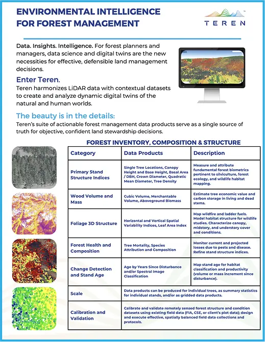
Analyses that quantify primary stand structure indices, wood volume, mass, and foliage 3D structure. Assess forest health, composition, stand age, and change through time at multiple resolutions.
The beauty is in the details
Learn more about how Teren’s products harness technology for a robust forest ecosystem and economy.