Introducing Terevue Geotech Module: Predictive Insight for Landslide Risk

Pipeline operators, asset managers, and environmental engineers are under growing pressure to monitor and manage geotechnical hazards like landslides. Dormant threats can awaken with a single downpour, and policies such as PHMSA CFR 192.613 and ADB-2022-01 are now clear: pipeline operators must move beyond reactive responses and demonstrate proactive, risk-based management before severe weather turns […]
Introducing Terevue Hydrotech: Real-time Flood and Scour Risk Intelligence for Pipeline Operators

Flooding doesn’t wait for maps to be updated. Yet too many asset managers and operators are still relying on legacy flood tools that were never built for today’s extreme weather—or the critical infrastructure they threaten. That’s why Teren is proud to introduce the Hydrotech Module—the latest addition to the Terevue Platform, purpose-built to help pipeline […]
How a Rain Event Validated Terevue’s Accuracy in Predicting Landslide Threats
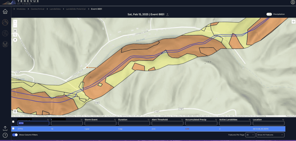
One operator’s experience proved that Terevue can catch the risks no patrol or instrument might see—until it’s too late. The Challenge Pipeline operators face an uphill battle when managing assets in landslide-prone regions. With limited instrumentation like inclinometers, most rely on aerial patrols and historical data to detect potential threats. But with traditional methods, not […]
Teren Launches Terevue to Revolutionize Environmental Risk Management for Infrastructure Operators With Real-time Geospatial Intelligence

New SaaS Product Is the First and Only Technology Offering System-wide Intelligent Alerting of Potential Environmental Hazard Events on Critical Infrastructure. DENVER, COLORADO, March 5th, 2025 (BUSINESSWIRE) — Teren, a leader in geospatial intelligence, is proud to announce the launch of Terevue, a groundbreaking cloud-based environmental intelligence platform that empowers pipeline operators and infrastructure managers […]
Introducing Teren’s Bi-Weekly Live Demos: Your Gateway to Advanced Environmental Intelligence

We’re excited to announce the launch of Teren’s bi-weekly live product tours! These live demos are designed to help you get the most out of Teren’s cutting-edge data suites, guiding you through the platform with real-time examples, practical advice, and answers to your pressing questions. Whether you’re just starting to explore Teren’s environmental intelligence capabilities […]
Introducing Terevue: The Future of Environmental Risk Management

Introducing Terevue! Integrate weather data, asset information, and threat-specific analytics into a single, user-friendly interface.
Teren Essentials vs. The Desktop Study: Harnessing Climate-Informed Geospatial Data for Enhanced Asset Resilience

In the face of a changing planet, the ability to harness dynamic data in reference to assets is critical for long-term sustainability and a cornerstone of asset resilience.
Processing LiDAR at the Speed of Light

Teren delivers information in a fraction of the time using Leica HxMap and the Teren Engine on the cloud. Note: This article was originally published as a case study by author Linda Duffy on Hexagon’s Leica Geosystems website. At that time, Teren was doing business as SolSpec. LiDAR data can be too much of a good thing. […]
Teren Launches Essentials to Mitigate Infrastructure Risk

New Essentials product helps businesses pinpoint the highest climate and environmental risk. DENVER, June 2, 2022 — Teren, the climate resilience analytics company, today announced the release of its new product, Essentials. Pipeline systems and electric transmission corridors can span thousands of miles through diverse terrain, soil, and geologic, hydrologic, climatic land use conditions — a varied landscape […]