No More Data for Data’s Sake: Cutting Through Pipeline Data Clutter

Pipeline operations and integrity teams are inundated with data. From LiDAR scans and IMU readings to photogrammetry, satellite imagery, and weather feeds, the volume of incoming information can feel paralyzing. As one panelist at Teren’s recent Operator discussion on weather and external force threats put it, the real challenge isn’t always a lack of data—it’s […]
Wildfire Ready: How the USDA-NRCS Is Using Environmental Intelligence to Prioritize Forest and Rangeland Resilience

Introduction With over 500 million acres of U.S. grazing lands under growing wildfire pressure, the USDA Natural Resources Conservation Service (NRCS) is advancing innovative strategies to address these challenges. Through the Rangeland and Forestland Fuel Management Hazard Zone Prioritization for Conservation Treatments project, commonly known as “NRCS Wildfire Ready,” the agency is piloting a scalable […]
Navigating Weather and External Force Threats in Pipeline Integrity: Key Insights from Industry Leaders

On March 3, 2025, Teren hosted an expert panel in Houston, bringing together leading pipeline operators and industry experts to discuss the evolving threats posed by weather and external forces. The panel featured a geohazard program representative from an industry partner, Jared Kowis (Enbridge), Moness Rizkalla (Visitless Integrity Assessment Ltd) and was moderated by Brian […]
The Evolution and Applications of Environmental Twin Technology: Webinar Insights

This article follows up on insights shared during the Pennsylvania Geospatial Coordinating Board’s recent webinar on AI-powered digital twins and quality of life innovations, featuring Kat Kraft, VP of Market Development at Teren. The environmental technology landscape is undergoing a remarkable transformation, with digital twins emerging as a powerful tool for understanding and managing our […]
Strange Bumps in the DTM: How Teren’s LiDAR Analytics Helped A Renewable Energy Investor See the True Terrain
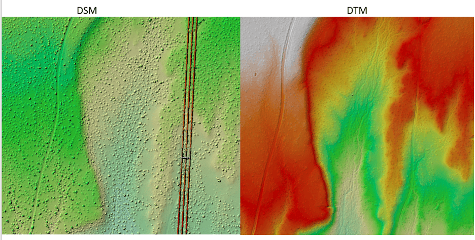
We think there are holes in the digital terrain model. That’s what an engineering firm flagged to Teren’s customer, a renewable energy investor, when they received Teren’s advanced LiDAR and analytics for a project on a solar generation facility out in Southeast New Mexico. Teren’s work with the renewable energy investor started early 2024 to […]
Understanding Post-Wildfire Hazards & Insurance Implications: A Conversation with Leading Geomorphologist John Norman

As wildfires like the recent ones in Los Angeles become increasingly prevalent across our landscapes, understanding their long-term impacts becomes crucial for land managers and insurance providers alike. We sat down with Teren’s John Norman, a geomorphologist with over two decades of experience studying post-wildfire landscapes, to discuss the critical risks and considerations facing professionals […]
Spooky Sightings from Above: Our Favorite Haunted Data Sets

Mappy Halloween from Teren! This October, we’re celebrating the spooky side of geospatial data. From the mapping of haunted sites around the world, to geospatial investigations of the paranormal. Check out our favorite picks below and get mapping! The Spookiest Places in the U.S. (and the Least Spooky) To look at how spooky U.S. metro […]
From Polar Bears to Landslides: A Geomorphologist’s Quest to Solve Nature’s Greatest Mysteries Through Soil

In his 25+ years as a geomorphologist, soil scientist and quantitative spatial ecologist, John Norman has navigated the realms of the impossible more than once. From predicting landslide risks to studying soil moisture, his journey has been one of transforming once “impossible” tasks into actionable science. But one project stands out: the time he was […]