Debris Flows: Understanding Nature’s Destructive Geological Phenomenon

Introduction Nature has few forces as swift and destructive as debris flows. These geological phenomena are more than just landslides – they’re powerful, unpredictable forces that can change terrain in an instant. They occur in a wide variety of environments and generally happen during intense rainfall or rapid snowmelt, often starting on hillsides or mountains. […]
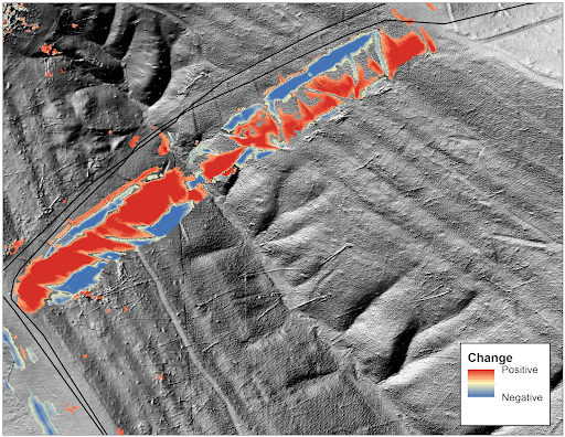
Predicting Landslides: Teren’s Hydrology Modeling Validated by Hurricane Helene

In the wake of Hurricane Helene, Teren worked with USGS data to validate its innovative approach to predicting landslides triggered by extreme weather events. Mapping the Risks: Before and After Helene The study used Teren’s slope stability analysis, which calculates a balance between resisting and driving forces in soil. The analysis began with a pre-Helene […]
Enhancing site suitability surveying: 5 key spatial data approaches for pre-construction site engineers and surveyors

For site engineers and surveyors, pre-construction surveying is a critical phase that sets the stage for a smooth construction process. Leveraging advanced analytics of grade, hydrology, soils, and vegetation can create highly useful “constructability” metrics that drive decision making for the rest of the project. Let’s explore 5 key spatial data approaches that can make […]
Transforming Well Pad Reclamation in Colorado’s DJ Basin

Learn how a major oil and gas producer has leveraged Teren’s environmental intelligence to become a leader in well pad reclamation. The Challenge: Well Pad Reclamation is a Complex, Regulated Landscape Well pad reclamation in Colorado’s Denver-Julesburg (DJ) Basin involves intricate processes and strict regulations. Companies acquire numerous assets over the years, and then often […]
From Polar Bears to Landslides: A Geomorphologist’s Quest to Solve Nature’s Greatest Mysteries Through Soil

In his 25+ years as a geomorphologist, soil scientist and quantitative spatial ecologist, John Norman has navigated the realms of the impossible more than once. From predicting landslide risks to studying soil moisture, his journey has been one of transforming once “impossible” tasks into actionable science. But one project stands out: the time he was […]
Slope Stability Explained, and It’s Relationship with Landslides
Have you ever wondered what makes a grassy hillside stay put instead of sliding down into a big Dali-like pile at the bottom? This primer explains the fundamental dynamics of how vegetation, soil moisture, and infrastructure interact to influence the stability of sloped terrain. Careful land management is crucial for slope safety and preventing landslides. […]
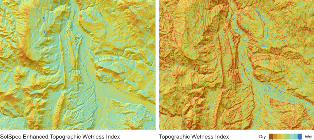
Elevating the Traditional Topographic Wetness Index with Teren’s Climate-Enhanced TWI

What is TWI? The Topographic Wetness Index (TWI) has long been a staple in modeling terrain moisture and watershed conditions. Widely accepted and frequently used, TWI serves as a crucial tool for ongoing land management decisions and actions. However, despite its utility, traditional TWI has significant limitations. Limitations of Traditional TWI While TWI is a […]
From Fire to Future: Using Spatial Analysis Tools for Wildfire Recovery in New Mexico

Wildfires: Balancing Prevention with Post-Fire Response With the ever-expanding 2024 wildfire season is off to a slow but steady start across North America, wildfires have become not a question of if, but when they will occur. While efforts to prepare for and prevent wildfires are important, efforts around rebuilding after a wildfire occurs are often […]
7 geologic hazards and their water-related triggers
Water is a powerful force that shapes our environment and influences a variety of geologic hazards. In this article, we delve into 7 geologic hazards and their water-related triggers, exploring how hydrology helps us understand and mitigate these dangers. What is Hydrology? Hydrology is the study of water and its movement, distribution, and properties in […]
Teren Awarded USDA Grant to Improve TWI Measure for Soil and Vegetation Delineation
Award from the USDA Natural Resources Conservation Service Teren is pleased to announce our pending grant with USDA Natural Resources Conservation Service. Our work with them will focus on creating a new and more comprehensive method for quantifying hydrological processes and soil moisture gradients to be used as a tool in delineating ecosystems, vegetation communities, and […]