Award from the USDA Natural Resources Conservation Service
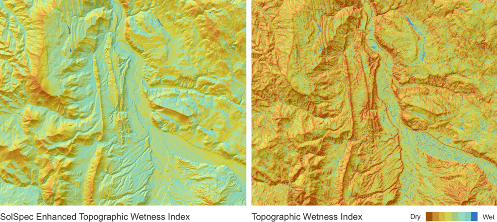
Teren is pleased to announce our pending grant with USDA Natural Resources Conservation Service. Our work with them will focus on creating a new and more comprehensive method for quantifying hydrological processes and soil moisture gradients to be used as a tool in delineating ecosystems, vegetation communities, and soil properties.A glimpse of the topographic wetness index (TWI). Blue indicates wet and brown indicates dry.
Who is USDA Natural Resources Conservation?
The USDA Natural Resources Conservation Service focuses on improving natural resources and land management. They do this through improving resource conditions, such as soil quality, water quality, water quantity, air quality, habitat quality, and/or energy efficiency. They work with farmers and ranchers to develop conservation plans and implement practices, including water development and vegetation improvements for livestock, improved irrigation systems, and forest management practices that address natural resource concerns on their land. They also promote land management research and data through partnering with federal and state agencies, universities, and professional services to deliver land management information.
What is TWI and how is it used in current land management practices?
Digital terrain indices to predict soil wetness generalize topographic variables that drive hydrological processes and are commonly used to help identify hydrological flow paths for geochemical modeling, as well as to characterize biological processes such as annual net primary production, vegetation patterns, and forest site quality” (source). TWI is an excepted analytic for local soil property (biogeochemistry) and ecosystem modeling (vegetation communities and wet land delineations), but limited when implemented over large landscapes. The index is generally extracted from a Digital Elevation Model (DEM), using the specific catchment area (D-infinity specific catchment area) and local hydraulic gradient under steady state conditions represented by local slope angle of the specific grid.
Why is the current TWI model deficient for accurate delineation of soil types?
TWI captures runoff flowing by gravity but fails to consider other factors. For example, locations with similar catchment area and slope can have significantly different soil moisture conditions due to varying characteristics in aspect, terrain, position, temperature, heat, and the soil physical and chemical properties induced by the solar radiation variance. The TWI model is used to simulate soil moisture gradients and/or conditions in a watershed; however, it is limited to steady state conditions. Ecosystems do not exist in a steady state. It does not consider factors, such as different soil moisture conditions due to varying characteristics in aspect, terrain, position, temperature, heat and soil physical and chemical properties induced by the solar radiation variance.To better capture this variability, Teren is working to develop an enhanced model.
Comparing the traditional topographic wetness index with the Teren enhanced topographic wetness index. You can visually see the impact that aspect and terrain plays on the moisture content in the enhanced index.
What is the benefit of Teren’s Triangulated Ecological Site Potential Model?
The model is highly dynamic and adaptable, capturing variability at multiple scales while adjusting input weight down network based on individual climatic or topographic driver importance. The weights of these drivers and how they impact the local or network soil moisture gradients can be adjusted based on local knowledge or new data. The resulting surface should prove useful for mapping soil (type, drainage, chemical, and physical properties), soil trafficability, and species- or community-based vegetation distributions. Ultimately, the model will help guide land management and operational decision making. It will aid in the grouping or discretizing landscapes for modeling purposes in CEAP-Grazing Lands, and for establishing ecological site and site group concepts for advancement of ecological site development efforts.
Models and tools of this type have the ability to aid in many unforeseen ways until a specialist determines a need and a use. For instance the TESP model could prove very useful in fire potential and severity prediction. By examining existing vegetation or forest stand composition and density against the TESP model output, dry hillslopes with high fuel loads could be isolated and prioritized for vegetation treatments, reducing the threat to public health and safety in the wildland urban interface .
So What?
Land management practices are undergoing a transformation through improved data collection and quality, particularly with drones, and increased processing power and analytics. Teren aims to enhance the current data offerings that inform land management plans so that decision makers can make better and more efficient decisions on managing the flora and fauna for which they are responsible.