What Makes a Good Hazard Model for Critical Infrastructure Operations? 6 Questions to Ask

Hazard models are everywhere, from FEMA flood maps to state landslide inventories to national wildfire indices. But not all models are created equal. For infrastructure operators (be it pipelines, utilities, transportation, renewables and beyond), integrity engineers, and damage prevention teams, these models directly influence decisions on where to deploy crews, how to prioritize integrity management […]
Death by Average: Why “100-Year” Floods and Landslides Keep Happening, and Average Risk Models Are Failing Us

If you feel like “100-year” floods are happening every few years, you’re not imagining things. The problem isn’t just the climate—it’s the math. For decades, engineers and emergency managers have relied on recurrence intervals like the “100-year flood” to describe the likelihood of natural disasters. But as extreme weather events grow more frequent and destructive, […]
Drowning in Uncertainty: 4 Ways Traditional Flood Models Fail Modern Infrastructure

Floods don’t wait for paperwork—and they definitely don’t care about boundaries on a decades-old map. But across the critical infrastructure industry, many asset managers are still forced to rely on outdated flood tools like FEMA maps and USGS gauges to plan for hydrologic risk. Here’s why that’s a problem—and what can be done about it. […]
Introducing Terevue Hydrotech: Real-time Flood and Scour Risk Intelligence for Pipeline Operators

Flooding doesn’t wait for maps to be updated. Yet too many asset managers and operators are still relying on legacy flood tools that were never built for today’s extreme weather—or the critical infrastructure they threaten. That’s why Teren is proud to introduce the Hydrotech Module—the latest addition to the Terevue Platform, purpose-built to help pipeline […]
Navigating Weather and External Force Threats in Pipeline Integrity: Key Insights from Industry Leaders

On March 3, 2025, Teren hosted an expert panel in Houston, bringing together leading pipeline operators and industry experts to discuss the evolving threats posed by weather and external forces. The panel featured a geohazard program representative from an industry partner, Jared Kowis (Enbridge), Moness Rizkalla (Visitless Integrity Assessment Ltd) and was moderated by Brian […]
Debris Flows: Understanding Nature’s Destructive Geological Phenomenon

Introduction Nature has few forces as swift and destructive as debris flows. These geological phenomena are more than just landslides – they’re powerful, unpredictable forces that can change terrain in an instant. They occur in a wide variety of environments and generally happen during intense rainfall or rapid snowmelt, often starting on hillsides or mountains. […]
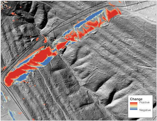
Predicting Landslides: Teren’s Hydrology Modeling Validated by Hurricane Helene

In the wake of Hurricane Helene, Teren worked with USGS data to validate its innovative approach to predicting landslides triggered by extreme weather events. Mapping the Risks: Before and After Helene The study used Teren’s slope stability analysis, which calculates a balance between resisting and driving forces in soil. The analysis began with a pre-Helene […]
Enhancing site suitability surveying: 5 key spatial data approaches for pre-construction site engineers and surveyors

For site engineers and surveyors, pre-construction surveying is a critical phase that sets the stage for a smooth construction process. Leveraging advanced analytics of grade, hydrology, soils, and vegetation can create highly useful “constructability” metrics that drive decision making for the rest of the project. Let’s explore 5 key spatial data approaches that can make […]
From Polar Bears to Landslides: A Geomorphologist’s Quest to Solve Nature’s Greatest Mysteries Through Soil

In his 25+ years as a geomorphologist, soil scientist and quantitative spatial ecologist, John Norman has navigated the realms of the impossible more than once. From predicting landslide risks to studying soil moisture, his journey has been one of transforming once “impossible” tasks into actionable science. But one project stands out: the time he was […]
Slope Stability Explained, and It’s Relationship with Landslides
Have you ever wondered what makes a grassy hillside stay put instead of sliding down into a big Dali-like pile at the bottom? This primer explains the fundamental dynamics of how vegetation, soil moisture, and infrastructure interact to influence the stability of sloped terrain. Careful land management is crucial for slope safety and preventing landslides. […]