Traditional pipeline safety and integrity management programs focus on the pipeline itself, yet a pipeline’s stability also depends on Right-of-Way (RoW) health and the surrounding environment.
After years of working with clients in Appalachia, a region that grapples with geological threats such as landslides, Teren has identified the top six external threat analytics that help pipeline operators take action sooner, save money, and ensure pipeline safety.
1. Change Detection
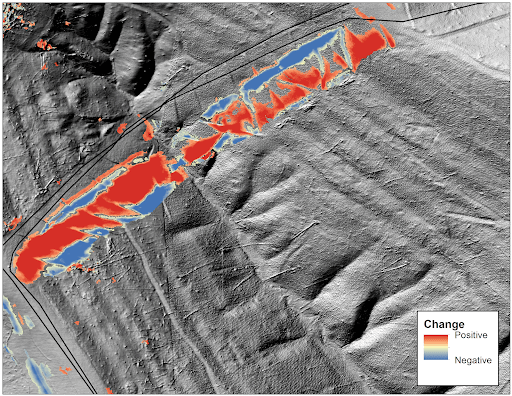
Advancements in high-resolution data collection and state-of-the-art analytics can identify and monitor ground movement over time to alert you of potential problems sooner. Change detection is derived from the comparison of subsequent Digital Terrain Model (DTM) collections that identifies subtle landform changes over time with an accuracy of +/- 10 cm.
2. Geohazard Identification & Ranking
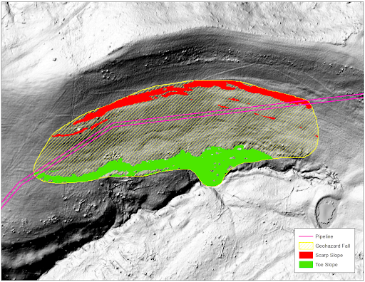
Geohazard prioritization is the cornerstone of why Teren’s process is different. Significant weather events and earth movement can quickly form geohazards that weren’t there before. AI/machine learning technology can find and rank active and potential geohazards including landslides, mudslides, karst, and river scouring to help operators prioritize resource allocation, inform risk mitigation, and maintain regulatory compliance.
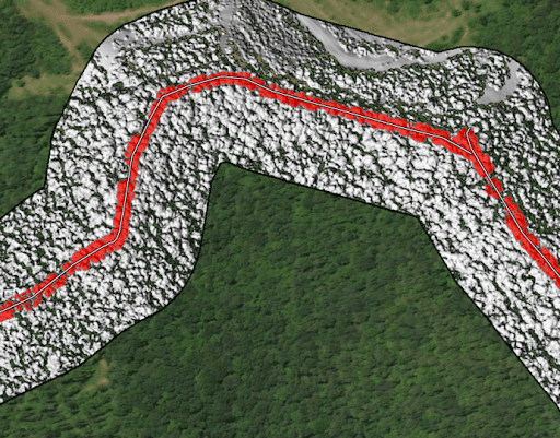
3. Surface Hydrology
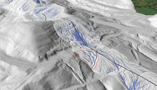
Geohazard risk assessments examine the flow of water on your project and the effectiveness of stormwater management and devices. Surface hydrology channels are ranked by flow power and direction that indicate where hydrology is threatening infrastructure and/or slope integrity. Operators can identify potential risks as well as monitor the effectiveness of hydrology management initiatives.
4. Structure Identification
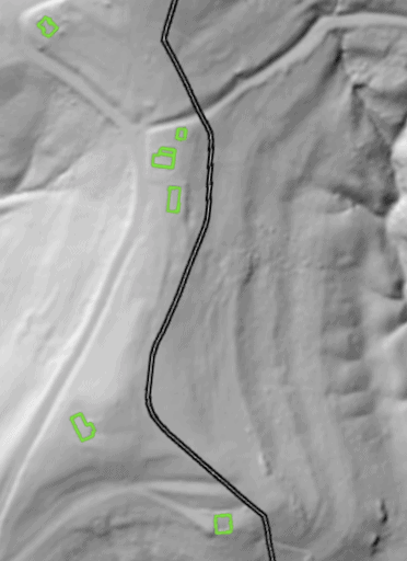
Detect and monitor encroaching structures along your operating areas. Structure identification is derived from the comparison of subsequent Digital Surface Model (DSM) collections that delineates where structures and new structures are encroaching on the RoW with an accuracy of +/- 40 cm.
5. Depth of Cover
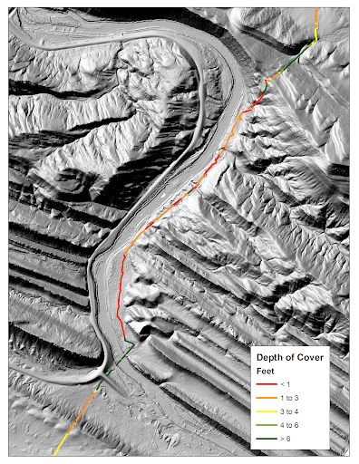
Identify pipeline exposure or minimal coverage that could lead to degradation from scour or third-party activities. When integrated with accurate centerline data, this analytics is an accurate way to measure the depth of cover for your pipeline system through time.
6. Vegetation Encroachments
Stay on top of maintenance, compliance, and slope stability needs by identifying vegetation height and structure. Vegetation management is derived from the DSM and multi-spectral imagery that assesses vegetation structure and health on your RoW.
Now, how to monitor all these threat analytics simultaneously, and in real time?
LiDAR, satellite and remote-sending providers can capture the high-fidelity data listed above that’s needed to evaluate the area surrounding your pipe, but they often deliver raw data rather than insights. That data then requires hours of expert analysis and significant IT infrastructure to derive actionable mitigation steps.
A (powerful) solution: Terevue
Powered by the Teren engine, Terevue is the only software solution that captures all the above analytics by collecting high-resolution LIDAR on regular intervals to monitor your landscape (3D) over time (4D). It then processes that data by combining GIS know-how, high-high-performance computing, and the latest in machine learning to allow customers to anticipate, prioritize, and alerts their teams in real time to evolving weather and environmental hazards threatening infrastructure integrity across entire pipeline networks.
To learn more about Terevue: click here.
Or go ahead and request a demo.