The Problem
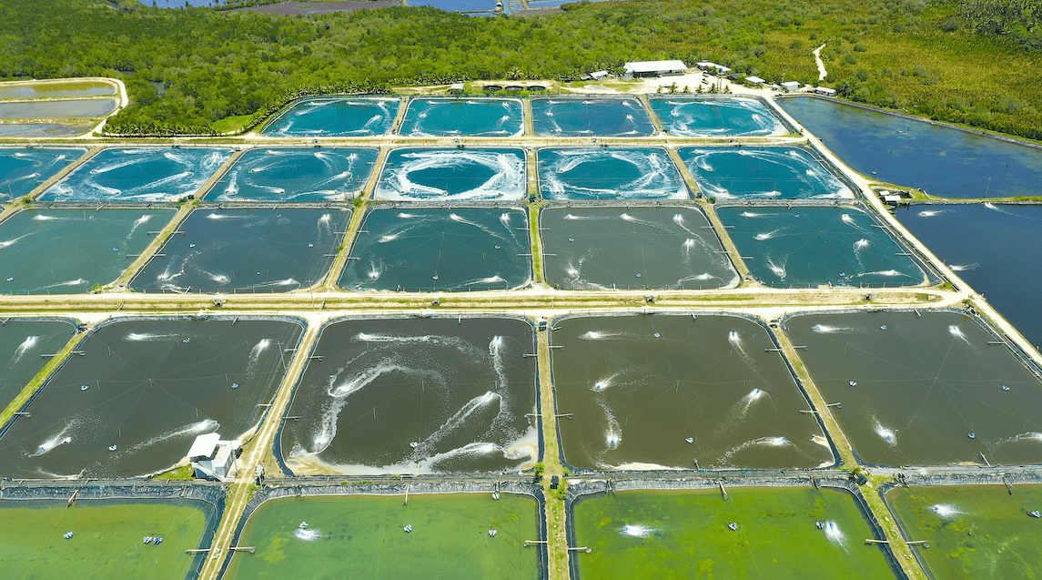
The client needed to convert an abandoned shrimp farm, the Milaflores Mitigation Site, into a restored wetland for the sale of compensatory mitigation credits. To evaluate feasibility and inform the wetland restoration design process, the client needed high-fidelity data to analyze and model the site. Traditional in-field land survey methods would require significant time and resources and rely on the sampling of site conditions with substantial interpolation between sample measurements. They needed a faster approach that wouldn’t compromise accuracy.
Teren’s Solution
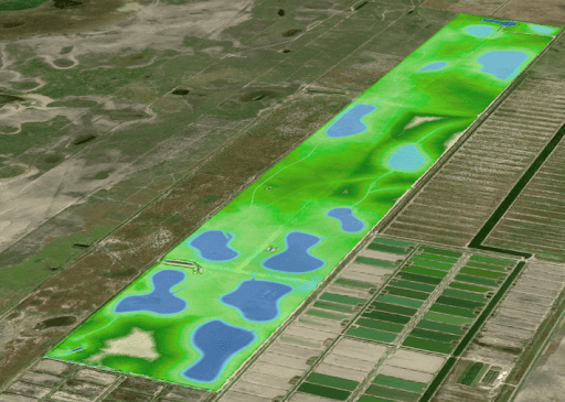
Teren acquired and analyzed high-fidelity terrain data to model the effects of wetland restoration activities planned for the 1,600-acre Miraflores Mitigation Site in Southern Texas.
The Miraflores Mitigation Site model was developed in three phases:
- hydrologic model development;
- modeling of current hydrologic conditions and validation of the model against field measurements; and
- modeling of hydrologic alterations per the site restoration plan.
Hydrologic Model Development
Teren developed a surface hydrology model to predict wetland potential using four sub-models including continuous surface hydrology, inundation zones, surface water accumulation, and flatness.
- The continuous surface hydrology model demonstrates how water flows and accumulates across the landscape, and it was weighted with outputs from the other three sub-models.
- The inundation zone model isolates low-elevation sites of probable pooling.
- The surface water accumulation model measures the distance and elevation differences between terrestrial locations and their nearest open water sources to generate a probability of surface water accumulation.
- Finally, the flatness model statistically identifies areas of little-to-no elevation change that, when combined with the other model variables, indicate the likelihood of successful wetland formation.
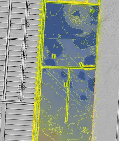
Modeling of Current Hydrologic Conditions and Validation
In order to quickly assess the hydrologic model’s ability to accurately predict wetland potential, Teren acquired high-fidelity (40-cm) light detection and ranging (LiDAR) data, processed the data into a terrain model, and then applied the hydrologic model to the terrain model. The hydrologic model remotely and successfully predicted current surface hydrology conditions and wetland locations prior to hydrologic alterations. The wetland mitigation banking firm satisfactorily validated the predictive accuracy of the hydrologic model against their field wetland delineations and measurements.
Modeling of Future Hydrologic Conditions
Teren integrated the hydrologic alterations proposed in the Miraflores Mitigation Site restoration plan into the terrain model created by the high-fidelity LiDAR datasets. Teren then applied the hydrologic model to the planned wetland restoration model to predict the impacts that restoration activities would have on surface hydrology and wetland potential for the Miraflores Mitigation Site.
Outcomes
Teren’s use of high-fidelity, continuous terrain models produced from remotely-sensed data reduced the time required for mitigation bank site design by months. It also improved the accuracy of hydrologic modeling underpinning site design. The methodology described above enabled strong agency confidence in the proposal during the review and approval process, further enhancing efficiencies and excellence for wetland restoration and compensatory mitigation projects.
To learn more about Teren’s restoration and hydrologic modeling services, visit our website.
Confidentiality Notice
The names and locations presented herein have been changed or generalized to protect project confidentiality. All other details are representative.