
From Dry Slopes to Disaster Zones: Why Landslide Modeling Needs a Rain Check

When do landslides actually happen? Not when the slope is steep—but when it’s steep, saturated, and pushed past its tipping point. And yet: most landslide models in use today ignore that final push. They tell us where landslides might occur based on slope and soil—but not when. And that omission is what leaves so many […]
From Tragedy to Resilience: How AI is Transforming Disaster Management
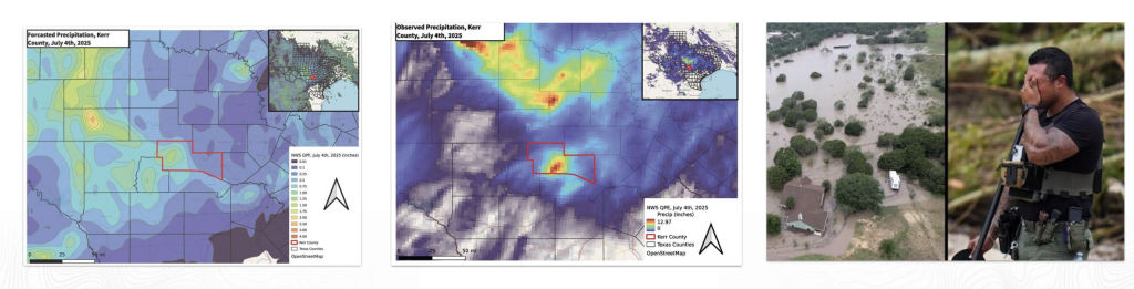
This article summarizes a talk that Teren CEO Toby Kraft gave at Enercom Denver August 20th, 2025. A Tragic 4th On July 4, 2025, communities in Texas Hill Country were blindsided by a 20-foot wall of water. In less than 90 minutes, a convective burst unleashed over 12 inches of rainfall – more than Denver’s […]
What Makes a Good Hazard Model for Critical Infrastructure Operations? 6 Questions to Ask

Hazard models are everywhere, from FEMA flood maps to state landslide inventories to national wildfire indices. But not all models are created equal. For infrastructure operators (be it pipelines, utilities, transportation, renewables and beyond), integrity engineers, and damage prevention teams, these models directly influence decisions on where to deploy crews, how to prioritize integrity management […]
Death by Average: Why “100-Year” Floods and Landslides Keep Happening, and Average Risk Models Are Failing Us

If you feel like “100-year” floods are happening every few years, you’re not imagining things. The problem isn’t just the climate—it’s the math. For decades, engineers and emergency managers have relied on recurrence intervals like the “100-year flood” to describe the likelihood of natural disasters. But as extreme weather events grow more frequent and destructive, […]
Introducing Terevue Geotech Module: Predictive Insight for Landslide Risk

Pipeline operators, asset managers, and environmental engineers are under growing pressure to monitor and manage geotechnical hazards like landslides. Dormant threats can awaken with a single downpour, and policies such as PHMSA CFR 192.613 and ADB-2022-01 are now clear: pipeline operators must move beyond reactive responses and demonstrate proactive, risk-based management before severe weather turns […]
Drowning in Uncertainty: 4 Ways Traditional Flood Models Fail Modern Infrastructure

Floods don’t wait for paperwork—and they definitely don’t care about boundaries on a decades-old map. But across the critical infrastructure industry, many asset managers are still forced to rely on outdated flood tools like FEMA maps and USGS gauges to plan for hydrologic risk. Here’s why that’s a problem—and what can be done about it. […]
Introducing Terevue Hydrotech: Real-time Flood and Scour Risk Intelligence for Pipeline Operators

Flooding doesn’t wait for maps to be updated. Yet too many asset managers and operators are still relying on legacy flood tools that were never built for today’s extreme weather—or the critical infrastructure they threaten. That’s why Teren is proud to introduce the Hydrotech Module—the latest addition to the Terevue Platform, purpose-built to help pipeline […]
How a Rain Event Validated Terevue’s Accuracy in Predicting Landslide Threats
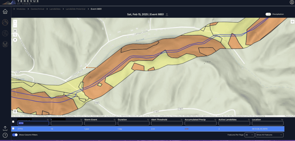
One operator’s experience proved that Terevue can catch the risks no patrol or instrument might see—until it’s too late. The Challenge Pipeline operators face an uphill battle when managing assets in landslide-prone regions. With limited instrumentation like inclinometers, most rely on aerial patrols and historical data to detect potential threats. But with traditional methods, not […]
Harnessing Geospatial Data and Machine Learning to Protect Your Pipeline

Pipelines face constant challenges from external, natural forces that can compromise safety and operational integrity. Geospatial data science has emerged as an innovative approach to better understanding, predicting, and mitigating these complex environmental risks. By leveraging advanced mapping technologies and sophisticated risk assessment tools, pipeline integrity engineers and operations managers can now anticipate potential threats […]
Announcing Our Strategic Collaboration with Woolpert

When you set out to be the best at providing accurate, timely and actionable environmental intelligence, you want to align yourself with companies who share the same values. Woolpert, a global leader in data acquisition, was an early data provider for Teren. Over the years, it became clear to our teams and theirs that there […]