From Dry Slopes to Disaster Zones: Why Landslide Modeling Needs a Rain Check

When do landslides actually happen? Not when the slope is steep—but when it’s steep, saturated, and pushed past its tipping point. And yet: most landslide models in use today ignore that final push. They tell us where landslides might occur based on slope and soil—but not when. And that omission is what leaves so many […]
What Makes a Good Hazard Model for Critical Infrastructure Operations? 6 Questions to Ask

Hazard models are everywhere, from FEMA flood maps to state landslide inventories to national wildfire indices. But not all models are created equal. For infrastructure operators (be it pipelines, utilities, transportation, renewables and beyond), integrity engineers, and damage prevention teams, these models directly influence decisions on where to deploy crews, how to prioritize integrity management […]
Introducing Terevue Geotech Module: Predictive Insight for Landslide Risk

Pipeline operators, asset managers, and environmental engineers are under growing pressure to monitor and manage geotechnical hazards like landslides. Dormant threats can awaken with a single downpour, and policies such as PHMSA CFR 192.613 and ADB-2022-01 are now clear: pipeline operators must move beyond reactive responses and demonstrate proactive, risk-based management before severe weather turns […]
From Overwhelmed to In-Control: A New, Smarter Framework for Pipeline Natural Force Threat Management

If you work in pipeline operations, you’ve likely felt the pressure of rising expectations—from regulators, customers, and your own team. The reality is that more data doesn’t always mean more clarity. It often means more noise, more confusion, and more liability. That’s why Teren created the Terevue Awareness to Action Framework—a 3 tier, risk-based approach […]
How a Rain Event Validated Terevue’s Accuracy in Predicting Landslide Threats
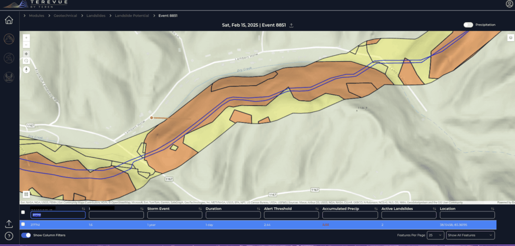
One operator’s experience proved that Terevue can catch the risks no patrol or instrument might see—until it’s too late. The Challenge Pipeline operators face an uphill battle when managing assets in landslide-prone regions. With limited instrumentation like inclinometers, most rely on aerial patrols and historical data to detect potential threats. But with traditional methods, not […]
Harnessing Geospatial Data and Machine Learning to Protect Your Pipeline

Pipelines face constant challenges from external, natural forces that can compromise safety and operational integrity. Geospatial data science has emerged as an innovative approach to better understanding, predicting, and mitigating these complex environmental risks. By leveraging advanced mapping technologies and sophisticated risk assessment tools, pipeline integrity engineers and operations managers can now anticipate potential threats […]
Navigating Weather and External Force Threats in Pipeline Integrity: Key Insights from Industry Leaders

On March 3, 2025, Teren hosted an expert panel in Houston, bringing together leading pipeline operators and industry experts to discuss the evolving threats posed by weather and external forces. The panel featured a geohazard program representative from an industry partner, Jared Kowis (Enbridge), Moness Rizkalla (Visitless Integrity Assessment Ltd) and was moderated by Brian […]
API RP 1187 Recommended Practice for Managing Landslide Hazards for Pipeline Integrity Explained, and How to Implement
Introduction to API Recommended Practices Landslides are complex geological phenomena that can have devastating effects on pipeline infrastructure and pose a significant threat to pipelines crossing complex terrain. They can be caused by both natural events and human activities and represent a constant risk to operations, especially in pipelines traversing mountainous or unstable areas. API […]
Strange Bumps in the DTM: How Teren’s LiDAR Analytics Helped A Renewable Energy Investor See the True Terrain
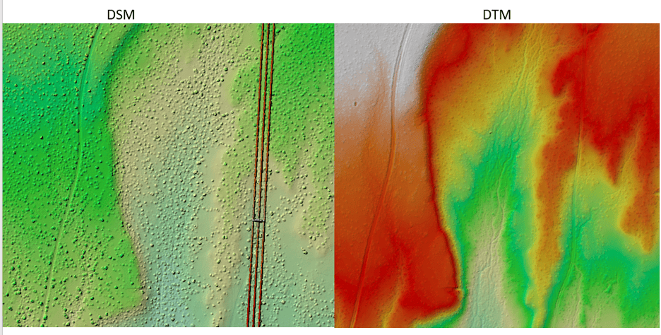
We think there are holes in the digital terrain model. That’s what an engineering firm flagged to Teren’s customer, a renewable energy investor, when they received Teren’s advanced LiDAR and analytics for a project on a solar generation facility out in Southeast New Mexico. Teren’s work with the renewable energy investor started early 2024 to […]
Debris Flows: Understanding Nature’s Destructive Geological Phenomenon

Introduction Nature has few forces as swift and destructive as debris flows. These geological phenomena are more than just landslides – they’re powerful, unpredictable forces that can change terrain in an instant. They occur in a wide variety of environments and generally happen during intense rainfall or rapid snowmelt, often starting on hillsides or mountains. […]