What Makes a Good Hazard Model for Critical Infrastructure Operations? 6 Questions to Ask

Hazard models are everywhere, from FEMA flood maps to state landslide inventories to national wildfire indices. But not all models are created equal. For infrastructure operators (be it pipelines, utilities, transportation, renewables and beyond), integrity engineers, and damage prevention teams, these models directly influence decisions on where to deploy crews, how to prioritize integrity management […]
Wildfire Ready: How the USDA-NRCS Is Using Environmental Intelligence to Prioritize Forest and Rangeland Resilience

Introduction With over 500 million acres of U.S. grazing lands under growing wildfire pressure, the USDA Natural Resources Conservation Service (NRCS) is advancing innovative strategies to address these challenges. Through the Rangeland and Forestland Fuel Management Hazard Zone Prioritization for Conservation Treatments project, commonly known as “NRCS Wildfire Ready,” the agency is piloting a scalable […]
Introducing Terevue Geotech Module: Predictive Insight for Landslide Risk

Pipeline operators, asset managers, and environmental engineers are under growing pressure to monitor and manage geotechnical hazards like landslides. Dormant threats can awaken with a single downpour, and policies such as PHMSA CFR 192.613 and ADB-2022-01 are now clear: pipeline operators must move beyond reactive responses and demonstrate proactive, risk-based management before severe weather turns […]
Introducing Terevue Hydrotech: Real-time Flood and Scour Risk Intelligence for Pipeline Operators

Flooding doesn’t wait for maps to be updated. Yet too many asset managers and operators are still relying on legacy flood tools that were never built for today’s extreme weather—or the critical infrastructure they threaten. That’s why Teren is proud to introduce the Hydrotech Module—the latest addition to the Terevue Platform, purpose-built to help pipeline […]
Harnessing Geospatial Data and Machine Learning to Protect Your Pipeline

Pipelines face constant challenges from external, natural forces that can compromise safety and operational integrity. Geospatial data science has emerged as an innovative approach to better understanding, predicting, and mitigating these complex environmental risks. By leveraging advanced mapping technologies and sophisticated risk assessment tools, pipeline integrity engineers and operations managers can now anticipate potential threats […]
Navigating Weather and External Force Threats in Pipeline Integrity: Key Insights from Industry Leaders

On March 3, 2025, Teren hosted an expert panel in Houston, bringing together leading pipeline operators and industry experts to discuss the evolving threats posed by weather and external forces. The panel featured a geohazard program representative from an industry partner, Jared Kowis (Enbridge), Moness Rizkalla (Visitless Integrity Assessment Ltd) and was moderated by Brian […]
Strange Bumps in the DTM: How Teren’s LiDAR Analytics Helped A Renewable Energy Investor See the True Terrain
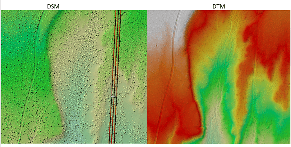
We think there are holes in the digital terrain model. That’s what an engineering firm flagged to Teren’s customer, a renewable energy investor, when they received Teren’s advanced LiDAR and analytics for a project on a solar generation facility out in Southeast New Mexico. Teren’s work with the renewable energy investor started early 2024 to […]
Enhancing site suitability surveying: 5 key spatial data approaches for pre-construction site engineers and surveyors

For site engineers and surveyors, pre-construction surveying is a critical phase that sets the stage for a smooth construction process. Leveraging advanced analytics of grade, hydrology, soils, and vegetation can create highly useful “constructability” metrics that drive decision making for the rest of the project. Let’s explore 5 key spatial data approaches that can make […]
Transforming Well Pad Reclamation in Colorado’s DJ Basin

Learn how a major oil and gas producer has leveraged Teren’s environmental intelligence to become a leader in well pad reclamation. The Challenge: Well Pad Reclamation is a Complex, Regulated Landscape Well pad reclamation in Colorado’s Denver-Julesburg (DJ) Basin involves intricate processes and strict regulations. Companies acquire numerous assets over the years, and then often […]
6 Key Analytics for Insuring Properties in Hazard-Prone Markets
Insuring properties in hazard-prone markets, such as homes located near wildfire risk areas, requires a specialized approach to risk analysis. The stakes are high, and the potential for catastrophic losses makes it crucial for insurers to leverage advanced analytics. In this blog post, we’ll explore the top analytics tools and techniques that are essential for […]