Pipeline operators, asset managers, and environmental engineers are under growing pressure to monitor and manage geotechnical hazards like landslides. Dormant threats can awaken with a single downpour, and policies such as PHMSA CFR 192.613 and ADB-2022-01 are now clear: pipeline operators must move beyond reactive responses and demonstrate proactive, risk-based management before severe weather turns into disaster.
Unfortunately, many teams are stuck reacting. Without the right data, thresholds, or tools to prioritize field inspections and remediation actions, they waste time, overspend budgets, and scramble to explain damage they never saw coming. That’s why Teren built the Terevue Geotechnical Module to change the game from reactive to resilient. And the results speak for themselves: across nearly 11,000 known landslides, 89% would have been detected in advance using Terevue’s alerting system.
The Geotechnical Module (or Geotech Module for short) is part of Teren’s Terevue Platform—a real-time environmental intelligence system built for infrastructure integrity. Designed specifically for pipeline and energy operators, the Geotech Module analyzes hillslope stability in relation to weather events to identify when and where existing and potential landslide threats become active.
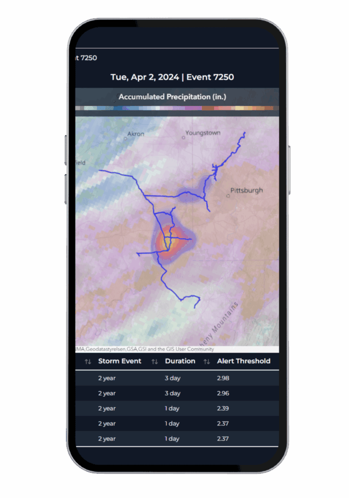
This isn’t your traditional landslide map. It’s a dynamic alerting system that uses location-specific terrain, soil, and climate data to forecast where a storm will tip the scales—from stable to unstable—and affect your assets.
Operators can subscribe to the Geotech Module through Terevue and receive timely, asset-connected alerts that translate environmental noise into focused, field-ready insight.
The Terevue Geotech Module is more than a monitoring tool—it’s the engine that powers a defensible, risk-based integrity management program.
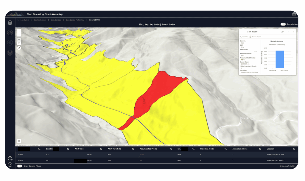
At its core is the Awareness to Action Framework, designed specifically for pipeline operators managing geotechnical threats. It transforms raw environmental data—like precipitation intensity, hillslope stability, and soil characteristics—into tiered, actionable insights that help teams make smart, justifiable decisions.
Here’s how it works in the field:
With Terevue’s Geotech Module, you’re not just overwhelmed with data, you have clear, tiered visibility, and the support to move from broad awareness to targeted inspection and mitigation. PHMSA doesn’t expect omniscience—they expect smart, risk-informed action. That’s exactly what Geotech delivers: a structured path to compliance, accountability, and confidence in your decision-making.
Proven Accuracy.
Terevue’s models are continuously validated and refined using real-world data. Read the Geotech Module Methods & Validation Paper
To date, most geohazard monitoring tools either drown you in false positives or arrive too late. Engineering firms may recommend expensive fixes, but they’re not watching your right-of-way every day. Generic weather platforms forecast conditions—they don’t connect them to slope failure. Terevue does both.
With the Geotech Module, you get:
✅ Proactive Remediation: Intelligent alerts help catch slope instability before it becomes slope failure—preventing environmental damage, outages, and costly emergency response.
✅ Remediation Prioritization: By correlating real-time weather with hillslope conditions, the Geotech Module helps teams focus only on the slopes that pose a real, immediate threat—saving millions by avoiding overengineering. In fact, Geotech alerts align with real-world landslide events at a rate of nearly 90%, significantly outperforming traditional hazard maps and models.
✅ Situational Awareness: Terevue replaces guesswork with clarity. Operators can now track evolving geotechnical threats on a daily basis, even in remote or tree-covered terrain.
✅ Compliance and Reporting: Alerts and storm thresholds are archived and exportable, giving teams the data they need to respond to PHMSA, API, or internal audit requests with confidence.
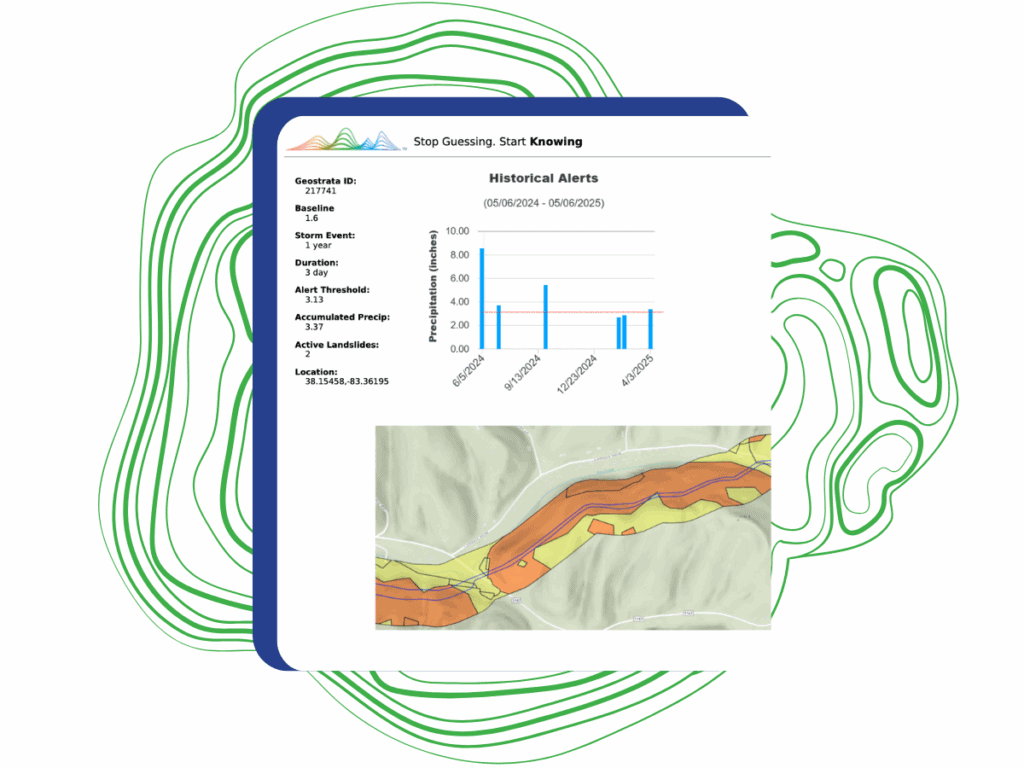
✅ Budget Justification: Historical alerts, factor-of-safety metrics, and storm thresholds provide concrete evidence for maintenance decisions—making it easier to defend inspection schedules and capital plans.
✅ Insurance Negotiation: Real-time geohazard monitoring and documented mitigations strengthen an operator’s risk profile—giving insurance brokers leverage to negotiate significantly lower premiums.
Terevue is the only solution that blends climate, terrain, and engineering intelligence into one platform designed to keep you ahead of landslide risk—no guesswork, no delay.
Ready to see where your next slope failure could happen—before it does?
Test Terevue on Your Terrain: Request a Historical Look Back