TEREVUE
Category Archives: Big Data
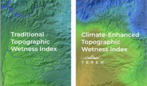
Elevating the Traditional Topographic Wetness Index with Teren’s Climate-Enhanced TWI
What is TWI? The Topographic Wetness Index (TWI) has long been a staple in modeling [...]
Jul
From Fire to Future: Using Spatial Analysis Tools for Wildfire Recovery in New Mexico
Wildfires: Balancing Prevention with Post-Fire Response With the ever-expanding 2024 wildfire season is off to [...]
Jul
Teren Applauds Introduction of Modernizing Wildfire Safety and Prevention Act
Teren commends the introduction of the Modernizing Wildfire Safety and Prevention Act of 2024, a [...]
Jun
Revolutionizing Post-Wildfire Recovery: A Case Study on Hermits Peak Watershed Management Project
Read Teren's case study on the Hermits Peak watershed management project completed in collaboration with [...]
Nov
Teren Kicks Off Nationwide LiDAR Content Library Program
Companies now have access to Teren data for operational assets and development projects across the [...]
Jul
How an AI-Driven Approach to Analytics Is Changing the Geospatial Industry
Teren’s AI-driven approach to remotely-sensed data and analytics was featured in a recent article by [...]
Jun
How Can Big Data Impact Land Reclamation?
Toby Kraft, Founder and CEO of Teren (formerly SolSpec), spoke about “Playing Offense and Being [...]
May


