TEREVUE
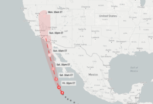
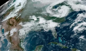
Unleashing Nature’s Fury: Hurricane Hilary’s Deluge Threatens California’s Fragile Balance
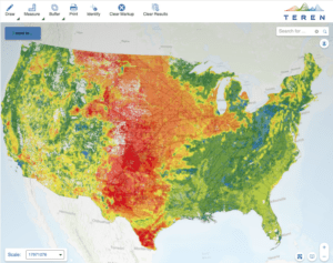
Hurricane Hilary reminds us of the urgent need of maintaining resilient infrastructure, monitoring environmental threats, [...]
18
Aug
Aug

Teren, Inc. Appoints Luc Vincent, AI Leader and Greentech Expert, as New Board Member
Vincent’s experience in AI, mobility, mapping, and greentech product innovation provides invaluable guidance to Teren.
26
Jul
Jul

More than Vegetation Management: How One Pipeline Transmission Operator is Leveraging LiDAR to Protect Endangered Species
A case study to identify and prioritize areas for vegetation management and areas to be [...]
20
Jul
Jul
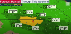
The Impact of Heavy Rain in an El Niño Year: Erosion, Flooding, and Infrastructure Risks in the Midwest
We’re evaluating how high rainfall in an El Niño year can lead to erosion, flooding, [...]
06
Jul
Jul
Enhancing Pipeline Inspection Efficiency in the Midwest through Remotely-Sensed Data: A Case Study
With many miles to inspect and a tight deadline, Teren helped the operator swiftly identify [...]
22
Jun
Jun
Storms in the Southeast: Keep Your Finger on the Pulse of Changing Environmental Threats to Your Assets
Understand the potential consequences of coupling environmental threats and severe weather on infrastructure.
15
Jun
Jun
Teren Essentials vs. The Desktop Study: Harnessing Climate-Informed Geospatial Data for Enhanced Asset Resilience
In the face of a changing planet, the ability to harness dynamic data in reference [...]
08
Jun
Jun
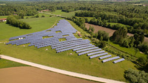
The Hidden Cost of Bad Data in Renewable Development
From estimating earthworks to designing array layouts, LiDAR plays a crucial role in determining the [...]
17
May
May
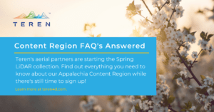
Sign Up for Spring: Top FAQ’s About Teren’s Content Regions
Teren's Spring 2023 Appalachia LiDAR collection is starting soon. Sign up today to get critical [...]
21
Mar
Mar
Webinar: Wildfire Season 2023 – How Well Do You Know Your Risk?
Learn how to leverage statistically validated and scientifically informed wildfire potential data to assess wildfire risk exposure.
26
Jan
Jan

Teren Expands Content Region Footprint to Include Oklahoma and Arkansas Data
Teren, the climate resilience data and analytics company, today announced it has expanded its analytics [...]
14
Dec
Dec

Don’t Be Left Out In the Cold: Teren Prepares for Fall Appalachia LiDAR Collection
Teren's Fall 2022 Appalachia LiDAR collection is the best and fastest way to get high-fidelity [...]
03
Nov
Nov

How AI Can Help Solve Climate Change
Teren was featured in a recent article by Jerry Ledford in LifeWire about the power [...]
18
Oct
Oct
Webinar: Gain a Competitive Advantage
With Teren, engineering firms and developers can access high-fidelity LiDAR and decision-ready analytics to gain [...]
16
Sep
Sep

Lakewood Climate-tech Startup Searches Wildfire Ravaged Land for Risks
Teren was featured in a recent article by the Denver Business Journal for its work [...]
08
Sep
Sep

Pipeline Regulatory Compliance for External Threats & Extreme Weather
The Federal Register published the final part of PHMSA’s Gas Mega Rule. But don’t worry, [...]
26
Aug
Aug
Teren Launches Hermit’s Peak Watershed Protection Analysis
Climate resilience analytics will offer actionable insights into Hermits Peak’s post-wildfire risks. Teren, the climate [...]
17
Aug
Aug
Teren Kicks Off Nationwide LiDAR Content Library Program
Companies now have access to Teren data for operational assets and development projects across the [...]
12
Jul
Jul

Top 4 Analytics for Renewable Developers
Renewable developers are in a hard space. On the one hand, they are in a [...]
06
Jul
Jul
Satellite Data for Building Climate Resilient Assets
Toby Kraft was interviewed for a recent article by Geospatial World. He touched on Teren’s [...]
28
Jun
Jun